The Kanawha Trace ~ State Route 73
Prepared by Merle C. Rummel


The Kanawha Trace ~ State Route 73
Prepared by Merle C. Rummel


The Kanawa Trace passed through Warren County (and Ohio) from Portsmouth on the Ohio River to Richmond, Indiana on roughly the same route as SR-73. It was a early migration route for people coming to southwestern Ohio and eastern Indiana from western Virginia and North Carolina. (Note the prehistoric route of the Teays River.)

Prepared by Merle C. Rummel
Argus Ogborn was a Quaker historian in Richmond, Indiana. He gave me a copy of his copy of the Bill of the Road, which he had found in a collection (unspecified) some years ago. He saw it for what it was, the mile by mile progress a Quaker settler would walk with team and wagon to travel to Richmond, but I recognized many of the named places in the Way Bill from travel, residency and research in these regions. From this I drew up and gave him a map tracing the path of the Trace. In researching families on this trace for my book on the Four Mile Church, I recognized that the Brethren used this as a major path from Virginia to Ohio. I had frequently asked myself a question about the route of the Dunkers in Virginia to Ohio and the West, since I had early found that most of them did not use Daniel Boone's Wilderness Road. (The Flat Creek Mission, Church of the Brethren, is right on the Old Warriors Path - Goose Creek, mouth of Mudlick, near Manchester, Kentucky, my parents lived there at the mission, Mudlick Station, head of Mudlick. I occasionally visited there, and I followed the path and story of Daniel Boone and the early Dunkers in the Kaintuck lands.) Only a few of the Carolina Brethren who followed the Wilderness Road into Kentucky, came up into Ohio. I've followed Forbes' Road and Braddock's Road in Pennsylvania, when I pastored at Beaver Dam (Maryland) and with my brother, who still pastors in Western Pennsylvania. Maryland and Pennsylvania Brethren, including some in the upper part of the Valley, would have used those routes and come down the Ohio on flatboats. But many early Dunkers lived much farther south in the Valley, and there was a major early settlement of the Brethren below Roanoke, on the front of the Blue Ridge in Franklin and Floyd Counties, the old Carolina Road, (Elder Jacob Miller families and neighbors) who came from there to western Ohio. The Kanawha Trace was their route. Virginia Dunker Family names are found along it.
The Kanawha Trace Bill of the Road, or Waybill, begins in the north central part of North Carolina where the Moravian Brethren, Friends (or Quakers) and German Baptist Brethren (Dunkers, Church of the Brethren) had major settlements. Early Dunker Churches were along the Yadkin River starting in Wilkes County, going east to Winston Salem, then south through Salisbury, this was the area from which Daniel Boone came.
The Waybill that we have, begins at New Garden Friends Church on the Northwest side of Greensboro, near Guilford Battlefield. Clemmons was likely at Guilford, a small town on North Carolina 66. By distance, Beesons would be the town of Colfax; and Kernersville, east of Winston Salem, is Kerners. Continuing on North Carolina 66 to U.S. 52, Bittings would likely be at Stanleyville or Rural Hall, Gordings would be at Pilot Mountain, and Unthanks at Mount Airy. Following the route of U.S. 52 into Virginia, Perkins would be at Cana Virginia and Mankins at Ward's Gap might be the modern Fancy Gap on U.S. 52 at the Blue Ridge Parkway. Going west the Trace went to Road's Fork at modern Hillsville on top of the ridge, where U.S. 52 and Virginia 100 each continue their own route down into the New River Valley. The Trace followed Virginia 100 down Little Reed Island Creek through Popular Camp Mountain. It crosses Reed Island River at Patterson and then the New River (Fugat's Ferry, now a bridge). Virginia 100 does not cross Draper's Mountain to Pulaski, and John Feeley's would be at McAdam or possibly Draper. Crossing Walker Mountain, Virginia 100 comes to Poplar Hill, which would be Shannon's and comes back to the New River, which has taken a big loop, at Pearisburg, old Giles Court House, and U.S. 460. Peter's Ferry could be located at Narrows, where they could recross the New River. (It must be remembered that in these early days, the lack of bridges in the frontier areas meant that obstacles that we now ignor drastically effected travel patterns. A Traveler sometimes went longer, or worse, routes, because there was no way they could cross a River. This is true of the routes here, and across West Virginia.)
Remember, also, that in those days Virginia went clear to the Ohio River. Across West Virginia, the Kanawha Trace, by tradition, followed the Shawnee Indian War Path close to the New or Kanawha River. Peterstown is just in West Virginia at U.S. 219 and West Virginia 12. Christian Peter's home would have been out of Peterstown on West Virginia 12. There Bozoo Road goes left and down into the old river bottom, a shorter route than West Virginia 12. Bluestone Lake floods this area, but the Indian River enters the New below Indian Mills, coming down the valley from the Northeast. The Blue Stone River comes up the valley from the Southwest about 15 miles down stream and Pack's ferry would have been out in the lake, between them (before Wolf Creek Mountain). Unless there was a bottom land route (now flooded), the mountains push in close to the New River and the Trace would have followed a trail up to Pipe Stem, and followed the Pipestem Creek down to the Blue Stone River crossing. Following up another trail out of the Blue Stone, Pack's could possibly be at Nimitz and Jumping Branch, where another old road (West Virginia 3) goes to Shady Spring. There modern U.S. 19 shows sections of an old road near it. U.S. 19 goes to Beckley, Mount Hope and Glen Jean (with Harvey just beyond) and on to Fayetteville on the downriver side of the New River Gorge. This is possibly "Road's Fork", where the Trace did not try to recross the New River, but took West Virginia 16, to Beckwith where it took the very rugged Falls Creek Road over Cotton Hill. The creek and trail come out at the Falls of the New River, now Kanawha Falls (where the Kanawha River Dam now is). The Gauley River enters the New River at Gauley Bridge above the Dam, and the River changed, it is larger, and has a more constant flow. The valley widens. It is now called the Kanawha. Here below the falls, early settlers built flat boats and floated down the River to Point Pleasant, then down the Ohio to Kaintuck or Cincinnati.
The Trace followed a country road along the south bank of the Kanawha River. It is pressed closely by high rugged mountains, the only level areas are where mountain streams enter the river. A couple of these have become towns, Deep Water, Eagle. Benjamin Morris probably lived where Montgomery is, where West Virginia 61 comes down off the mountain. There is a better roadway, and towns of Crown Hill and Cabin Creek. At Chelyan the West Virginia Turnpike and U.S. 119 come down to the River. Leonard Morris had a fortified log house ("fort") at Marmet, on the south side of the River just above Charleston, where the Toney's and others fled during the Indian raids of 1794. Venables would have been in the eastern area of South Charleston called Kanawha City, where there used to be a second branch of the Kanawha River by that name. Cobb's would also be in South Charleston near Vandalia. The Coal River enters the Kanawha at St. Albans, where U.S. 35 comes in from downstream and Ohio. There is quite a ridge, actually a mountain, between the two nearly parallel rivers for many miles. Hanley's, M'Collister's and Grice's would have been stops on the lower river before crossing to Gallipolis Ohio. The Trace followed the bank of the Kanawha River clear to the Ohio, then down the bank of the Ohio to across from Gallipolis, because of high ridges along both rivers. At Gallipolis, they would have rafted over the Ohio, landing at the old town dock area, today's City Park.
An alternate route, known to be used by the Indians and some settlers, followed Moss Creek out of Beckley, one of the headwaters of the Coal River. It then followed the north bank of the Coal River through Blooming Rose to St. Albans, where Coal River empties into the Kanawha; part of this is now West Virginia 3.
At Gallipolis, the Kanawha Trace followed Gen. Lewis' Army Road to Chillicothe (after the Battle of Point Pleasant, 1774, he pushed the Indians back to their main city, building a road for his cannon, now U.S. 35: remnants of Old 35, and likely the Trace, are seen in various places through the valleys either side of the new road). The Army Road, and the Trace, started in downtown Gallipolis. Old 35 goes out of Gallipolis north of the old city and goes along Chicamauga Creek inland almost to Mills before it crosses the creek. This probably was the original route. (The creek enters the Ohio River south of Gallipolis, but swings north behind most of the city before it turns inland. It is quite swampy. Chillicothe Road, a street in the south part of Gallipolis crosses the swamps with a bridge and goes west till it junctions with Ohio 588 going on to Rodney. Ohio 588 starts in Gallipolis at the city park and bridges the top end of the swamp.) At Rodney, the Jackson Road is Old 35. Crossing Raccoon Creek at Adamsville, Woods was certainly Wood's Mill. The Trace then went on to Rio Grande, where the Adamsville Road is north of U.S. 35, actually the back drive on Bob Evans farm. Judge Poor's (or Squire Poor) was at Winchester, south of 35 at Ohio 327. This is the original Old 35, or Gallipolis Pike, now called Dixon Run Road. Jackson is still a major Ohio town, the town and trace are both south of modern U.S. 35. Richmond is now called Richmond Dale, and is on a stretch of the old road north of modern U.S. 35. Kilgore's Ferry over the Scioto River is at the bridge on U.S. 35/50, north of the mouth of Paint Creek. The Trace angled into Chillicothe on Eastern Ave (Jackson or Gallipolis Road). It then turned up Hickory Street to Main Street, and went west past the State Capitol. Chillicothe was the first Capitol of the State of Ohio. It had been a major Shawnee Indian center and is still noted for its Hopewell Indian mounds (Mound City). There were early settlers with Dunker family names along this stretch of the Trace, but we have no record of churches.
Leaving Chillicothe, the Kanawha Trace followed the Zane Trace out of town on the Limestone Road (now Western Ave; Limestone was the original name for Maysville Kentucky, the destination of the Zane Trace). They went west along Paint Creek (U.S. 50). Elijah Johnson's would be north of Bourneville, and the Trace followed an old Indian trail that went west up a wide valley. The road is called Lower Twin, and goes to South Salem. From the Covered Bridge on Lower Twin, just west of So Salem, the Trace went north off the present road and kept to the highlands (going directly in front of Robt Smalley's house, which now sits far back a lane from the road) to Greenfield, where it forded Paint Creek on the rocky bottoms, just south of town (the old Fall Creek Church was farther south, west of Paint Creek on Fall Creek). From there, the Trace turned westward and crossed Rattlesnake Creek at Monroetown (East Monroe, on Ohio 28), to Leesburg (U.S. 62 and Ohio 28), and on west to Joel Willis', now Highland, where the old Lexington Church was just south of town. In Highland, the Trace turned north on Wilmington or Antioch Road. This is the same old winding Trace until it gets to Wilmington, where the Antioch Road met old 73, which turned west on the trace into town. Old 73 now dead ends at the Airport, heading directly toward the control tower.
The Trace went westward from Wilmington to Waynesville, along Ohio 73. It crossed Todd Fork Creek and at Caesar's Creek State Park went north at the "Y," going through Harveysburg, where it wound down to Caesar's Creek (now under the reservoir). The Trace went to Corwin where it forded the Little Miami into Waynesville. Corwin is north of 73, the Trace separated at the Cemetery. It went up into the north part of Waynesville, and came back out on Ohio 73 on the west side of town. The Trace (and Ohio 73) continue on west to Springboro and Franklin along the present route (the Old Upper Springboro Pike to Waynesville coming into Franklin on 2nd Street). In the 1870's the ferry was replaced by a suspension bridge on 4th Street, later by the present Lion Bridge on 2nd Street.
At Franklin, the Trace forded the Great Miami River below the 6th Street RailRoad Bridge, then William Barkalow started a ferry at his house in 1804 (at the trestel). The Trace went back north along the river and turned west, Ohio 123, past Rev Tapscott's house (in front of his Primitive Baptist Church), just east of the town of Carlisle. The Trace continues on from Carlisle, until it crossed Twin Creek, there it turns on Sugar Street to Sunsbury and stayed south of Germantown and Big Twin Creek. At the five points, it went ahead (to the right) on the Mudlick and Sigel Road to where Henry Moyer lived, and where it met the road going west out of Germantown (Ohio 725). The Trace continues along 725 to Gratis. Keep right at the Y into Gratis, and Ohio 122 is the old winding Trace angling northwest to Eaton, where St Clair's Fort still stood from the Indian Wars. From Eaton, U.S. 35 follows the Trace to Richmond, Indiana. Whitewater Meeting was founded 1809, in a log church at a cemetery that stood almost directly under the U.S. 27 overpass, just beyond the railroad tracks (200 feet west of the old brick church at North G street).
Danuel DuBois traced his route from Monmouth County New Jersey to Carlisle in his diary in 1804. From Chillicothe to Franklin his route matches those of the Waybill. He averaged 40 miles per day. This is the first known use of the Trace across the state.
Dunker settlement here was very early. Some of the children of Elder Jacob Miller from Franklin County Virginia, in the 1790's came up the Great Miami to Dayton, then by 1803, moved west to the state line. Philip and Anna (Miller) Lybrook followed the Trace in 1806, when he returned to Virginia and brought his wife and families of married children back to Indiana (Upper Four Mile Church). They came by wagon. From Eaton he came west on the Old Dayton Road (Dayton through Eaton and Boston, Indiana, to Conners Trading Post, 1803).
The Trace leaving Chillicothe was not in existence when the first Quaker came into Ohio, Nathaniel Pope, settled Leesburg in 1802. He left Chillicothe on the old Indian Path to Old Chillicothe (now U.S. 35 to Xenia) along the North Fork of Paint Creek. At Col. Massie's settlement, Frankfort, Pope went southwest to Leesburg. The path of the Trace from Chillicothe to Leesburg was a shortened route from his settlement. The Trace was not in existence in 1802, it was used clear across the state by 1806. The Waybill was after 1809.
The Kanawha Trace is very important to the settlement of Southern Ohio. The Quakers and Dunkers, and many others from Southern Virginia and North Carolina, followed it as they came to Ohio Country. It was probably the most used land route for migration into Ohio in the years before the Old National Road (c 1827).
Assistance on this study was given by several people living in communities along the route of the Trace. Especial thanks is to be given to Rev. Robert Roller, pastor of the Fraternity Church of the Brethen, Winston Salem, North Carolina; Stan Bumgardner, Historian, West Virginia Division of Culture and History, Charleston, West Virginia; and Harriet Foley, Franklin, Ohio. Parts of the route through Virginia and West Virginia were determined from known locations, using U.S. Topographical Maps.

The Kanawha Trace Way Bill
New Garden, Guilford County, North Carolina Bill of the Road to
Richmond, Indiana, Crossing the Blue Ridge at Ward's Gap, and
traveling the Kanhaway Route
-------------------------------------------------------------
(facing page)
To:
Clemmons - - -- - - 4 4 Peters' - - - - - - - 3 142
Beesons - - - - - 5 9 Mouth of Indian River- 7 149
Kerners - - - - - 3 12 Pack's ferry - - - - 10 159
Bitting's - - - - 17 26 Blue Stone River - - 5 164
Gording's - - - - 14 43 Pack's - - - - - - - 6 170
Unthank's - - - - 14 57 Hervey's - - - - - - 17 187
Perkin's - - - - - 4 61 Blake's - - - - - - - 6 193
Mankins' - - - - - 8 69 Road's fork - - - - - 16 209
(At Wards Gap) Cotton hill - - - - - 6 215
Cornelius' - - - - 5 74 (4 m. over)
Road's fork - - - 6 80 Falls of New River - 5 220
Reedisland River - 14 94 Benjamin Morris's - - 8 228
Fugat's Ford Leonard Morris's - - 17 245
of New River- - 1 95 Venables' - - - - - - 5 250
John Feely's - - - 5 100 Cobb's - - - - - - - 7 257
Walker's Mountain- 15 115 Coal River and Coal
Shannon's - - - - 3 118 Mountain in the way to
Thos. Kirk's - - - 9 127 Hanley's - - - - - 18 265
Giles Court House- 2 129 M'Collister's - - - - 12 277
Peters ferry - - - 3 132 Grice's - - - - - - - 16 293
Peters town - - - 7 139
-------------------------------------------
(reverse page)
Ohio River - - - - 9 302 Leisburg, in Highland
700 yds wide -Galliopolis County, Ohio - - - 3 396
Woods Joel Willis's - - - - 4 400
on Rackoon Ck- 11 313 Morgantown - - - - - 4 404
Judge Poor's - - - 15 328 Wilmington - - - - - 10 414
Town of Jackson - 8 336 Todd's fork Creek - - 3 417
Scioto Salt works. Caesar's creek - - - 10 427
Coonts's - - - - - 11 347 Little Miami at
Richmond - - - - - 5 352 Waynesville - - - 3 430
Highbank-Prairies- 5 357 Springborough - - - - 8 438
Kilgore's ferry - 5 362 Franklin on the
(Scioto) Great Miami - - - 4 442
Chilicotho - - - - 4 366 Tapscott's - - - - - 2 444
Elijah Johnsons on Big twin Creek - - - 4 448
Paint Creek - 9 375 Eaton - - - - - - - 17 465
Greenfield - - - - 12 387 White Water Meet House
Rattlesnake creek RICHMOND --------- 16 481
at Monroetown- 6 393
- "This Bill may not be precisely correct in every instance" -
-------------------------------------------------------------
(Foolscap paper - before 1820) obtained from Argus Ogborn, Quaker Historian, Richmond, IN. New Garden was in Greensboro, NC - the Whitewater Meeting (Richmond) was begun 1809)

Link to excerpts of Merle C. Rummel’s books, including Four Mile Community. Also, see Ohio Migration Trails by Maggie Stewart-Zimmerman.

The New River arises in North Carolina, high in the Appalachian Mountains, passes through the Blue Ridge Mountains, the Ridge and Valley and the Allegheney Plateau, 340 miles before it merges with Gauley River to form the Kanawha River a tributary of the Ohio River. The New-Kanawha system, while flowing principally northward, forms the only river that flows completely across the Appalachians from east to west and yielded the Kanawha Trace.
The New River is widely accepted as the oldest river in North America and the second oldest river in the world. The Wisconsin Glacial Period (20,000-25,000 years ago) radically altered the geography of North America north of the Ohio River. The ice was a mile thick when it began its retreat, Springboro being very close to the southernmost extent of the Wisconsin Glacier.
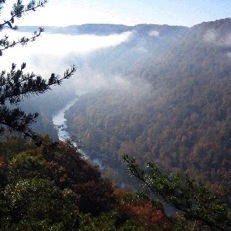
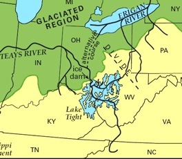
The New River Canyon Pre-glacial Teays River

© 2011-2022